 Geek Prepper Survival Skills when SHTF!
 It’s so easy to pull out your smart phone and use a map app or GPS app to navigate to your chosen destination. What if GPS ceases to function, or if you want to avoid being tracked by your cell phone carrier? Using a map and compass is a fool proof system to find your way.
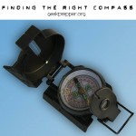
Using a map and compass
Items you’ll need:
- Map of your immediate area
- Compass
Pick A Destination
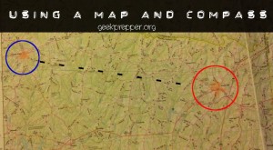
I picked 2 random cities on a page of a Delorme Atlas for our example.
Today we’re going from point A (Red Circle) to point B (Blue Circle). Red Circle is the spot you need to bug out from, and Blue Circle is your safe haven.

Plot your course
Use a straight edge to determine the desired line of travel.

Place the long edge of your compass along the straight edge, following the path of the straight edge

Get your Compass set properly
Rotate the direction dial housing on your compass so that it’s N (North) points to magnetic north on the map.

Hold your compass and turn in place until the red compass needle points to North on the compass dial’s housing (it’s the red N)
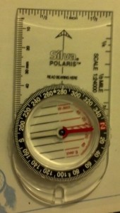 Now your “Direction of Travel” arrow points to the heading for your desired line of travel.
Navigating to your destination
Try to find a landmark along that line in the distance and head towards it. After you reach that landmark use your compass to locate another landmark along the same path and repeat this process until you arrive at your desired destination.
In an Emergency the roads may not be the safest route to travel, forcing you to bushwhack through the country side. If you have Maps and a Compass, you can still get to your goal. Sometimes the old way is the right way. Make sure you are familiar with using a map and compass so you know how to navigate if modern technology fails or if you need to avoid using roads.